 We took a taxi to the Bahnhof and then
took the bus to the Kehlsteinhaus,
We took a taxi to the Bahnhof and then
took the bus to the Kehlsteinhaus, which is a
bit of cheating since it is already at 1837 meters. But this is ok
because it was was already 10:30 when we started and this is the way I
wanted to go in any case.
which is a
bit of cheating since it is already at 1837 meters. But this is ok
because it was was already 10:30 when we started and this is the way I
wanted to go in any case.Christine and I started out late from the hotel, with our new
packs. We took a taxi to the Bahnhof and then
took the bus to the Kehlsteinhaus, which is a
bit of cheating since it is already at 1837 meters. But this is ok
because it was was already 10:30 when we started and this is the way I
wanted to go in any case.
To reach the Hoher Göll from the Kehlsteinhaus, you have to
traverse the Mannelsteig. This looks easy. It's not.
  People go out in full gear just for this
climb. We didn't have helmets or full harnesses.
People go out in full gear just for this
climb. We didn't have helmets or full harnesses.  We did have special safety ropes with
dual carbiners to clip to the iron cables bolted to the sides of the
rocks. We just tied these to our belts. This is
not recommended but the point is not to fall in the first place. When
I have done this trip before, I used only a light rope, and only at
the last part of the climb, mostly depending upon my intention to hold
on to the cables at all times.
We did have special safety ropes with
dual carbiners to clip to the iron cables bolted to the sides of the
rocks. We just tied these to our belts. This is
not recommended but the point is not to fall in the first place. When
I have done this trip before, I used only a light rope, and only at
the last part of the climb, mostly depending upon my intention to hold
on to the cables at all times.
I knew Christine could do this because I had seen her handle
herself well on the
Hochkalter the year before. I had warned her
that this was somewhat more difficult, but it is difficult
to anticipate how difficult. At one point she wanted to turn around
but that was only briefly. Halfway through, she was accoustomed
to the climb.
The reason the traverse is difficult is that you don't get to walk
over the top of the ridge. You have to go up and down the steep sides
of the ridge. Deep down
and back higher up. All the while looking out over the steep valley
at the mountains to come.
Deep down
and back higher up. All the while looking out over the steep valley
at the mountains to come.  But the
time you get to the foot of the Hoher Göll proper, where it meets the
climb down to Purtscheller Haus, we'd taken a good three hours.
But the
time you get to the foot of the Hoher Göll proper, where it meets the
climb down to Purtscheller Haus, we'd taken a good three hours.  Then it is a long steady hike up to the
top.
Then it is a long steady hike up to the
top. What is discouraging about climbing the
Hoher Göll is that the summit is always further away than you
think. But it's doable and we reached it at 16:00.
What is discouraging about climbing the
Hoher Göll is that the summit is always further away than you
think. But it's doable and we reached it at 16:00. 
This was very late in the day and we were already very tired from hauling our pack up to this 2522 meter peak, up and down over the Mannelsteig and then up to the peak. And we were still a long ways from shelter. On the way up, we had been warned not to attempt this so late in the day because of danger of thunderstorms. I was aware of this but really wanted to make this trip today because we didn't have a lot of days. I was aware at breakfast that we were starting late, but I prayed to the mountain that it would let us by today. This was no sure thing as we had seen a thunderstorm in the mountains the day before as we had dinner.
I had brought a bivouac bag and an emergency plastic blanket in case of a storm. My thought was that we could hide out in a cave or crevice until it passed, but I hoped we wouldn't have to. We could have gone down to the Purtscheller Haus, but was still another four hours and we would have have to restart the Bergtour somewhere else the next day. I really wanted to go on to the Stahlhaus, which wasn't that much further away in hours, because the Purtscheller Haus required a steep descent down sheer cliffs.
So we went on. The next peak was very close: unnamed on my map and
about as high as the Hoher Göll. But we
could see easily what we were going to go over.
But we
could see easily what we were going to go over.  Then we made a traverse arond a steep
valley. We again couldn't go on top of the ridge but the way across
the bottom of the ridge cliff was easy. There were a few places where
we crossed snow and I had to be careful as my weight was often not
suported by the snow the same way Christine's was.
Then we made a traverse arond a steep
valley. We again couldn't go on top of the ridge but the way across
the bottom of the ridge cliff was easy. There were a few places where
we crossed snow and I had to be careful as my weight was often not
suported by the snow the same way Christine's was.
Thank goodness we had finally hit snow. I was counting on this. I and Christine
were each carrying about 1 1/2 liters of water which we consumed on
the way up. We filled up our big bottles with snow so that it would
melt. I carried a 1 liter plastic bottle slung on the bottom of my
pack so that it would catch the sun as well as swing around, melting
the ice. We had to refill our bottles several times during this
day.
I was counting on this. I and Christine
were each carrying about 1 1/2 liters of water which we consumed on
the way up. We filled up our big bottles with snow so that it would
melt. I carried a 1 liter plastic bottle slung on the bottom of my
pack so that it would catch the sun as well as swing around, melting
the ice. We had to refill our bottles several times during this
day.
This was relatively easy. Christine kept checking her cell
phone.  There were only a few places where we had
to go down and climb back up to altitude again.
There were only a few places where we had
to go down and climb back up to altitude again. It was long but with beautiful
scenery. Christine kept checking her reception.
It was long but with beautiful
scenery. Christine kept checking her reception.  . As we moved clock-wise on the
half-circle we were making in the mountains, we had good views of
where we had climbed in the morning and early afternoon.
. As we moved clock-wise on the
half-circle we were making in the mountains, we had good views of
where we had climbed in the morning and early afternoon.
At the end of this traverse, near the foot of the climb to the
Archenkopf, we paused for food. There was
in principle another escape route here down to the valley, but it was
very rugged and the weather was holding. So we climbed up to 2392
meters, our highest peak, and started walking over the great long
ridge of mountains towards the Hohes Brett, which was still some
distance away.
There was
in principle another escape route here down to the valley, but it was
very rugged and the weather was holding. So we climbed up to 2392
meters, our highest peak, and started walking over the great long
ridge of mountains towards the Hohes Brett, which was still some
distance away.
Sometimes the scenery below us was wild.  We could see our next goal of the Hohes
Brett and then see that there would have to be a descent and climb
first.
We could see our next goal of the Hohes
Brett and then see that there would have to be a descent and climb
first.  Repeatedly, we wished for a bridge. We
kept getting closer.
Repeatedly, we wished for a bridge. We
kept getting closer.  And
Christine kept checking her cell phone.
And
Christine kept checking her cell phone. 
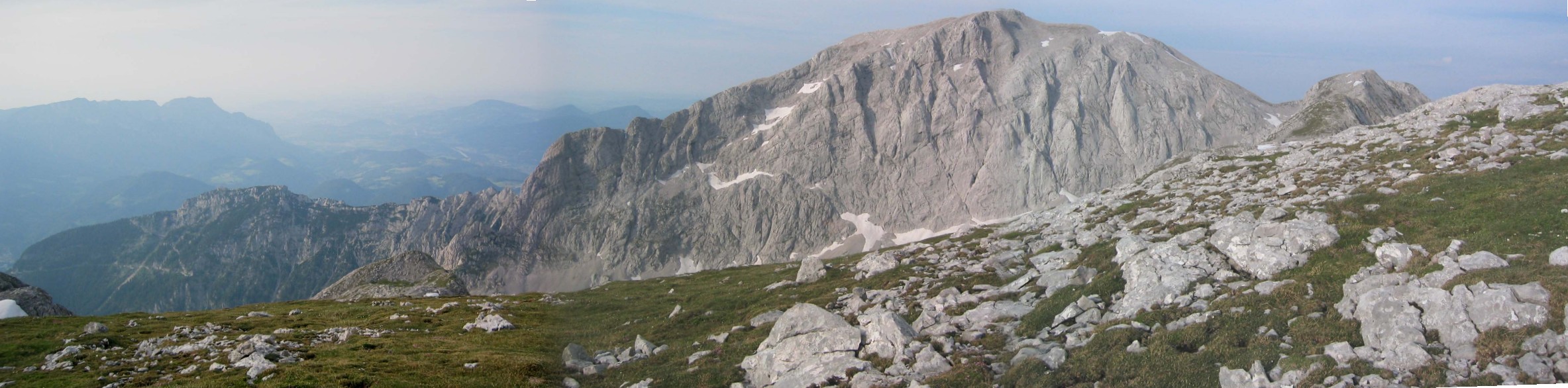
As we got to the the other side of our half circle, we could really
see a panorama of where we had been: 


Eventually, we reached to Hohes Brett at 2331 meters
 and then
started more steeply downhill.
and then
started more steeply downhill. This was still easy and we were
overjoyed when we reached the sign that pointed towards our
destination.
This was still easy and we were
overjoyed when we reached the sign that pointed towards our
destination.
However, we were still far from home. We finally reached the Jeagerkreuz at 2182 meters. Now, it was all a steep downhill climb to the Stahlhaus at 1728 meters. This was a more rugged downhill climb than we would have liked for the last part of our climb. I lost one of my water bottles on the way and had to go off trail and climb down the cliff to get it though it wasn't difficult.
Eventually we rached the Stahlhaus. Christine got there first and just sat, exhausted, at 21:00. We'd climbing and hiking for over 10 hours. When a guy asked her which way she had come and she told him, he told her she was crazy. But we had a small supper and a good sleep in the lager. (Note: a sleeping mask and ear plugs are essential for sleeping side by side with a bunch of strangers.)
One note is that most of the time we had been hiking on the border between Germany and Austria. The Stahlhouse is on the border but in Germany and the sign on the phone warns users that the phone is a German one.