MAP from Nauders to Fluelapass
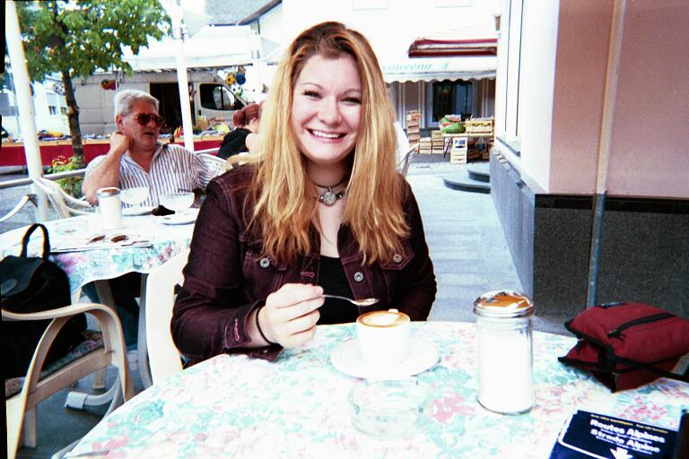
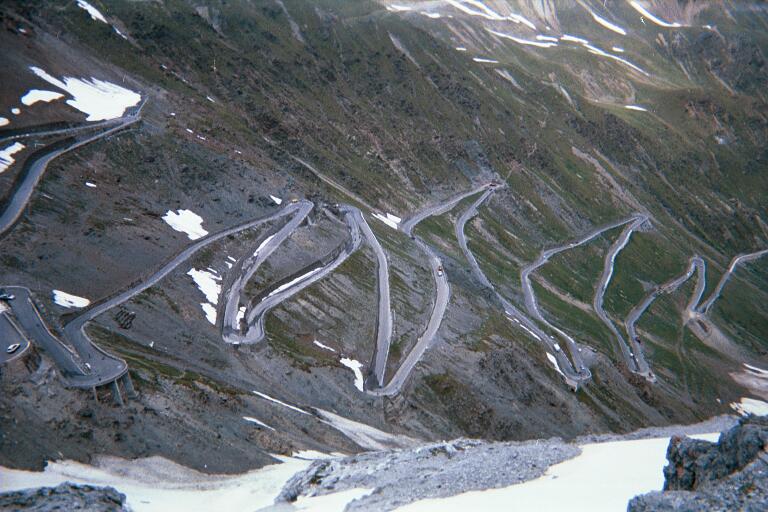
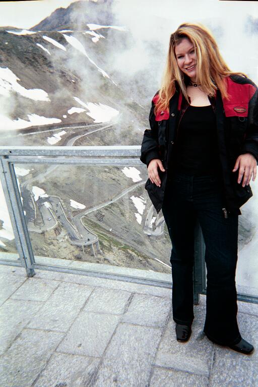
We did the same trip to Stifser Joch Pass as I had done previously, filling up as we leave. Yesterday, I filled up the tank half-way twice, so it was probably a 200 km + day yesterday. We did stop in the valley in Gomagoi so that Lauryn could have a a real Italian cappucino in a real Italian town. Lauryn was starting to complain about the seat. First, it is a stock seat and even hurts me. Second, we both have large posteriors and she is partially sitting on the back rack bar. But after climbing the road to this pass, she says she really gets why motorcycling is so much fun. She also buys a pin with a motorcycle and a picture of the road.
We have lunch at the little Tibetan restaurant. The view from the open terrace is magnificent but we have to first go inside and persuade the servers that we really want to eat out there. There are no other customers and the servers think it is too cold to eat on the terrace. It is cool, but we have out moto gear on and enjoy it. Lauryn is delighted to hear that the restaurant below us is playing U2's best hits. We have a great lunch and discover when we get the bill why all the other motorcyclists are eating wurst down below.
We go down the backside, but at Sta. Maria, we go left on the 28 in the direction Zernez, staying in Switzerland this time. We almost catch up with some bikes going down but later on we are passed by what seem to be Goldwings passing cars on curves with abandon. Well, there's always someone crazier than you. I am over-constrained by my desire to show Lauryn the Stilser Jock pass, and also go to Grindelwald avoiding the Autobahen. I have not bought the expensive Swiss sticker and would rather go through the mountain roads anyway.
We stop for gas in the little town of Tschierv. The station is staffed by a young boy and girl who can barely understand my German. We're in the Romanche part of Switzerland and they don't know much German from school yet. They're really cute.
I heard Lauryn start to sing in the back. I let her know that all motorcyclists sign in their helmets, as far as I know, one time or another. I couldn't explain why. Often for the rest of the trip, I could hear her singing, and could sometimes even identify the song. For example, "Temptation Waits" from Garbage Somewhat strange to hear in the Swiss Alps.
In Zernez, we take a right on the 27/28 for a short way to Susch and the left at Susch on the 28 to get to the Fluela pass. It's clouding up and on the way up, it starts to rain. It's very pretty in the rain, that's one thing. I have forgotten to bring two pairs of rain pants. I brought Lauryn's motorcycle jacket but not her pants. So She gets the rain pants. But the rain is gentle and off and on. By the time we get to the back side of the pass, it lets off and it is just cold. This was pretty much the pattern for the rest of the long day.
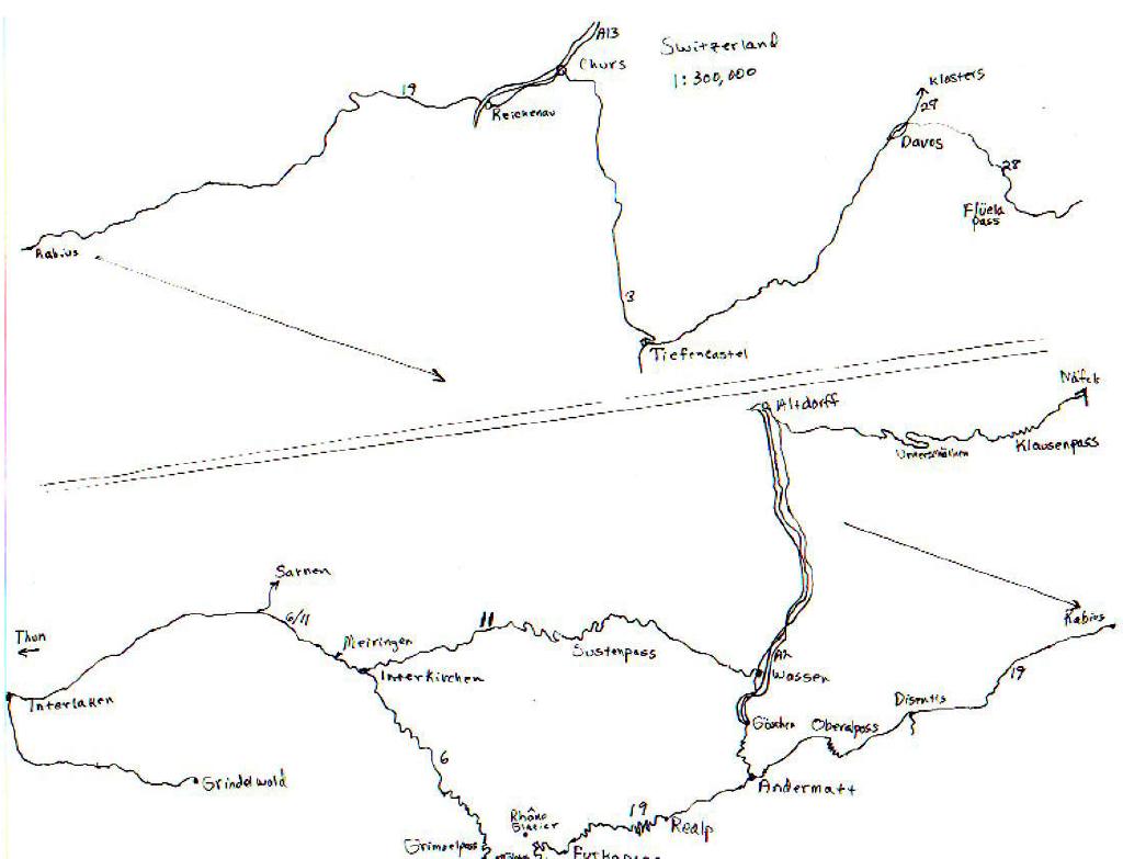
MAP from Fluelapass to Rabius to Furkapass to Grindelwald
We ride through Davos and to Tiefencastel. Lauryn is really bothered by the seat now. When I stop at the crossroads to take a leak, she lies down flat on a nearby flatbed trailer. We go on up to Chur on the 3. As usual, I think I am bailing by not aiming for more nearby passes. My road greed is out-of-control. And as Lauryn notes, what looks short on the map isn't, because the map doesn't show all the little curves and towns that make each mountain traverse so slow. We continue to see lots of bikes and continue to see lots of aggressive road usage by both motorcycles and cars.
In Austria, the motorcycle warning signs have been replaced mostly with one sign that just shows a motorcycle with a set of road warning signs in the background, and the words, in English, "No Risk, No Problems". The guardian angel sign survives only on the Autobahn. In Switzerland, the signs are largely gone from last year, though there are a few on the Furka Pass still.
In Chur, we fill up, and I have used nearly a whole tank. On the map, it looks like a clear and easy shot to Andermatt via the Oberalppass on the 19. Avoiding the Autobahn, we ride along the Rhein. This is the beginning of the river and we will be following the Vorderrhein, which is one of the smaller rivers that creates the big one. But just after Reichenau, the weather turns ugly.
We start climbing up the mountain and I can see a big storm blowing in. I turn around and race it back down the hill to shelter where we don the raingear we had taken off in Chur. The storm looks dangerous to me and I think Lauryn will be uncomfortable in the cold mountains in the rain, so I suggest giving up for the evening. But she wants to press on. It's great having a daughter who is game.
We pressed on. Just about the time the storm hit hard, we entered a long tunnel. This was wonderful. And when we came out the other side, the storm had passed. It did rain lightly on and off but I always dried out enough in between showers so that it didn't matter.
On the map, it was only about 50 km to Andermatt, but not only was the going slow due to mountain curves and rain, but along about the little town of Joergenberg, when the road was pretty big and fast and I had begun to be optimistic, there was a policeman standing in the road stopping traffic. He wasn't telling us what to do - just waving us off to wait on the side. Eventually, I went up and asked. There had been a traffic accident and the road was blocked. He directed us down a side road. We wound our way down into the Vorderrhein valley into a small village where other people directed the stream of vehicles back into a woodlot where the road ended. I was beginning to be concerned but a policeman there assured me that this was really going to be the way to Andermatt.
Suddenly, the convoy started up and we went down a small dirt, muddy, rutted backroad. This went down and down and finally crossed the river on a small bridge. Then we went up and up. Thank goodness for dirt experience. It was very slow going as we were in between cars in a long convoy. Eventually we hit the pavement again and wound our way on a backroad on the other side of the river through small villages. After a long way, we were able to cross the river again at Disentis and get back on the 19. Now it was just a short way to the Oberalppass, aptly named.
This is another wonderful road. I should mention that on all of these mountain pass roads, there are bicyclists climbing the mountains, or whizzing down. So you have to watch for them as well as the cars you pass. It was now cold and I switched to warm gloves and turned on my heated jacket. This gave Lauryn a chance to lay on the ground again for a few moments.
Andermatt is a beautiful little city, but we didn't stop except to try to get gas. The stations were all closed now and on automatic. But the pumps wouldn't accept any of my cards - not even my German Euro bank card. At the gas station, walking around, Lauryn noticed a peacock in a tree and found it very funny that peacocks hung out in Swiss mountain towns.
Onward to real mountain pass country. Even though it was getting late, my road greed would not allow me to take the shorter route to Interlaken. Instead, we stayed on the 19 in the direction of Realp to the Furka pass, as I had done last year. This year it was very cold and late so I didn't stop, but it is a must on a tour of the passes.
From there it was the same as last year, down to Gletch, take a right on the 6, and go over the Grimselpass. It's also beautiful and on the way up, we stopped and looked back over the valley to the Rhone glacier that we had passed on the Furka pass. Ok, now it's time to press on and get to Grindelwald. In theory, it's not too far and we get over the pass at about 9:30pm.
So we're zipping down the 6, often coasting to conserve gas, in the direction of Meiringen. But at the village of Handegg, the road is blocked and the sign directs us to a little road left up into the mountain. This quickly becomes a dirt road. It's dark and we are winding our way up this track on the side of the mountain and I am not completely sure we are doing the right thing as we are going so far.
I stop in the dark woods to take a leak and let Lauryn lie on the ground again. And then two bikes, I had seen resting in town, come through the road. OK, it must be the right way. Or at least we're not lost alone. We get back on the bike and I catch up to the guys so that we have a convoy. It takes a very long way, but eventually we hit the main road again. The two bikes streak off.
We see them again at a gas station. I pull in, but I still have no luck. They are having the same gas worries. The pumps say they take only Swiss cards and they are German. It turns out they are trying to get to Grindelwald also. We compare maps to make sure we're going the right way and then they zoom off - seems like they don't think and old heavily loaded bike could keep up with their sport bikes, but I don't mind. I just want us to get to bed.
From here on, the road is the same as last year, and I get us to the hotel at about 11:30pm. It's still jumping. We go up and unpack and wash. Lauryn is wasted and complains that she will never ride a motorcycle again because her butt muscles are permanently injured. I have to think of how to fix the seat.
Hotel Alpenblick
Postfach 91
CH 3818 Grindelwald
Awitzerland
41 33 853 11 05
FAX 33 853 44 84
www.grindelwald.net
www.swissalphotel.ch/
62SF / person-night
Nevertheless, Lauryn says she will meet me in the bar for a drink. She finally comes down at 12:25 and the bar closes in five minutes, but Ursula, one of the nice young ladies from last year, serves us anyway. Then Lauryn, now refreshed, goes out to the night club. I make sure she has money and knows the code for the night door, and go to sleep. It was a long trip, only about 470 km of mountain roads and rain and detours, and it was 13 hours on the bike, and I never hear Lauryn come in later in the morning.
Part 8: Grindelwald, Lindau, and Schek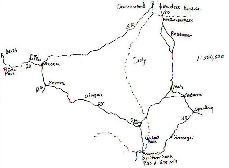